

Biographies of Some of the More Famous Cartographers
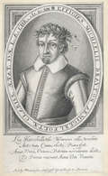
Pierre DU VAL
The early years of Du Val’s career were devoted to his atlas projects, while later in his career he was to concentrate on separately published, and often multi-sheet, maps. His first atlas was the Cartes Geographiques Methodiquement Divisees published in 1654. This contained only a few of Du Val’s own maps with the others comprising those of Sanson, Briet, Boisseau and even those of the earlier Dutch mapmakers, Mercator, Blaeu, Hondius and Jansson. The atlas was re-issued in 1655 and 1667, and the title was altered to Cartes De Geographie Les Plus Nouvelles Et Les Plus Fideles. These later issues contained more of Du Val’s own maps but were still very much supplemented by the maps of other makers.
Du Val also specialised in producing parlour games, games designed to teach geography and even snakes and ladders! Small sized works also formed part of his output as did geographical tables, genealogies and chronologies. Other early works by Du Val included La Geographie Francoise, La Geographie Universelle, Cartes Pours Les Itineraires and Cartes Des Provinces Eschues A La Reine amongst others.
Du Val dies in 1683 and the business was continued first by his widow Marie Desmaretz and then by his daughters.
The DANCKERTS
Koeman writes in his Atlantes Neerlandici that, “the grandfather, father and sons were all highly skilled and excellent artistic draftsmen and engravers. Their cartographic work has, compared with that published by the Blaeus or Janssonius, attracted little attention and has never received proper recognition”. The maps from the Danckerts world atlases may be characterised by the lack of verso text, the lack of coats of arms, ornaments and figures, and also their large-scale. In each of these respects they differ from the maps being produced by their contemporaries. However, the maps are always finely engraved and are generally found in attractive original wash colour.
The Family DE L'ISLE
Claude de l’Isle (1644-1720) was a geographer and historian working in Paris, but was overshadowed by his more famous son, Guillaume (1675-1726), who is probably the greatest figure in French cartography. Having learnt geography from his father, it is said that at the age of eight or nine he could draw maps to demonstrate ancient history. He studied mathematics and astronomy under J.D Cassini, where he received the grounding in scientific cartography, that is the hallmark of his work.
His first atlas was published in about 1700, in 1702 he was elected a member of the Academie Royale des Sciences, and in 1718 he became ‘Premier Geographe du Roi’. His maps of the newly explored parts of the world reflect the most up-to-date information available and did not contain fanciful detail in the absence of solid information.
His work was important as marking a transition from the maps of the Dutch school, which were highly decorative and artistically-orientated, to a more scientific approach. Guillaume reduced the importance given to the decorative elements in maps, and emphasised the scientific base on which they were constructed. The modern school of cartography has emerged from this discipline.
De L’Isle also played a prominent part in the recalculation of latitude and longitude, based on the most up-to-date celestial observations. His major contribution was in collating and incorporating this latitudinal and longitudinal information in his maps, setting a new standard of accuracy, quickly followed by many of his contemporaries. Guillaume De L’Isle’s reputation was such that pirated versions appeared in many countries, most particularly by Chatelain and Covens and Mortier.
After his death in 1726 the business was continued by his nephew Philippe Buache, and subsequently by J. Dezauche.
Joseph Nicholas de l’Isle (1688-1768), Guillaume’s brother, became a friend of Peter the Great and supplied him with information on the Russian Empire. He stayed in Russia for twenty-two years and was in charge of the Royal Observatory in St. Petersburg. He returned to France in 1747, taking with him much of the material he had access to, particularly relating to explorations along the northern Pacific coasts of Russia and America, which he subsequently published. The Atlas Russicus was published in 1747 and contained twenty maps.
Jean Baptiste D'ANVILLE
Parisian Jean Baptiste d'Anville (1697-1782) was a royal geographer and cartographer at the Louvre in Paris, compiling over 200 maps. D'Anville was particularly careful to mark unknown areas as blank and note doubtful information, giving his maps a slightly empty look compared to those of his predecessors. Characterised by accurate and careful work, his maps of the ancient world are particularly valuable. He was recognised with election to the Académie des Sciences in 1773.
James DUNCAN
James Duncan was a publisher of Paternoster Row, London. He was the London publisher of John Lothian’s “County Atlas of Scotland”, which was sold as individual sheets from 1827 and published in atlas form from 1829. He was also responsible for the publication of “A New Atlas of England and Wales” in 1833. Later editions of this atlas appeared re-using maps by W.Ebden and engraved by Hoare and Reeves.
John James DOWER
John James Dower (b.1825), the son of John Crane Dower (d.1847), was a map engraver working out of London throughout the latter half of the nineteenth century with premises in Pentonville and Fleet Street. John James succeeded his father in the family business and was responsible for such works as “Penny Map Of London, Or Exhibition Guide” (1851) and “Environs Of London” (1862). He also engraved maps for “The Weekly Dispatch Atlas”.
Johann Gabriel DOPPELMAIER
Johann Gabriel Doppelmaier [or Doppermayr] (1677-1750) was an astronomer and cartographer of Nuremberg. His “Atlas Coelestis”, published by Homann in 1742, was one of the major celestial atlases of the eighteenth century. Only one edition of the atlas was made, but some maps had been previously published by Homann, either bound into atlases or issued as separate sheets
The Family DIDOT
The Didot family were prolific printers, publishers and booksellers of Paris. Francois (d.1758) had two sons; Pierre the elder son and Firman the younger son. Firman inherited the type foundry in 1789 and was responsible for a number of works ranging from travel to poetry (he was also a poet in his own right). He in turn ceded the business to his sons c.1828.
Louis Charles DESNOS
Louis Charles Desnos (1728-1805) was a renowned mapmaker, globemaker and publisher of Paris. Throughout his considerable career Desnos worked with most of the eminent cartographers of his day. He came to control plates by Buy de Mornas, Brion de la Tour and Robert de Vaugondy amongst others and re-issued works by de Fer and Le Rouge. All this at a time when Paris could still be regarded as one of the largest centres of European map production.
Desnos’ works included a wide variety of cartographic subjects. Notable works include the “Petit Atlas Elementaire …” (c.1865) and the “Atlas National Et Génèral De La France” (1790) as well as many more.
Jean-Claude DEZAUCHE
French cartographers of the eighteenth century became renowned for their theoretical approach to cartography. Phillipe Buache (1700-1773) and Jean-Claude Dezauche (fl.1770-1824), as successors to the influential Guillaume De L'Isle, were at the forefront of this theoretical approach.
Buache’s family were great rivals of the Robert de Vaugondy family and it was Philippe Buache’s output as a mapmaker that made the family name synonymous with the prevailing theoretical cartography. Buache had married De L’Isle’s daughter in 1720 and entered the Depot des cartes et plans de marine in 1721. In 1729 he was appointed “premier geographe du roi”. Buache’s output was considerable throughout his career and on his death his widow sold the geographical collection to Jean Nicholas Buache de la Neuville, Philippe’s nephew.
Dezauche acquired the work Buache in 1780, having bought it from Jean Nicolas, as well as the work of many other geographers and cartographers (including De L’Isle). He made his own alterations and improvements to the works, and then re-published them in an improved and up-to-date form.
Samuel DUNN
Samuel Dunn was a mathematician, teacher, astronomer and cartographer, working in London in the 1770 and 1780s. His particular interest was in the problems of ascertaining longitude at sea, on which he wrote a number of books and pamphlets.
The “New Atlas” was the primary atlas that he produced, published successively by Robert Sayer and John Bennett, then Sayer alone, and then by his apprentices Laurie and Whittle. The maps are highly regarded for their accuracy, and the skill of execution, which allowed the incorporation of considerable detail.
The Family DONCKER
Hendrik I (1626-1699) was father to Hendrik II (1664-1739), both of whom were publishers in Amsterdam and were renowned for their maritime works.
Hendrick I published a number of sea atlases and pilots including his “Lichtende Colomne Ofte Zee-Spiegel", the “Zeeatlas Ofte Waterwereldt”, a “Nieuw Groot Stuurmans Zeespiegel”, a “Nieuw Groot Stuurmans Straetsboeck”, a “Nieuwe Groot Europa Wassende Grade Paskaer”t and a “Groote West-Indische Paskaert”. Doncker also published some portolan charts and various pilot guides in condensed form. Although he was competing with others such as Goos, Lootsman and Van Loon at this time, Hendrik achieved a considerable level of success – his work was for the most part original and his attention to detail and the continual up-dating of information on his charts, as that information became available, ensured his reputation.
Perhaps the most important edition of Hendrik’s “Nieuwe Groote Vermeerderde Zeeatlas” was published by his son, Hendrik II c.1705. The sea-atlas was continually being improved and up-dated (having itself grown from the “Lichtende Columne Ofte Zeespiegel”) and enjoyed a long publication life-span. Hendrik II saw the addition of charts with increasing latitudes to the atlas, and published the work in its most complete form.
Source:
I.C.Koeman, Atlantes Neerlandici Volume IV, pp.153-189.
Michael DRAYTON
 Michael Drayton (1563-1631) was an English poet who composed the Poly-Olbion. This was illustrated with one of the most unusual series of county maps ever published. The Poly-Olbion was a series of poems, or songs, extolling the beauties of the English and Welsh countryside, and was first published in 1612.
William Hole, who also engraved maps for Camden’s Britannia, was commissioned to provide the maps to illustrate these songs. Drayton states that each map is “lively delineating ... every mountaine, forrest, river and valley; expressing in their sundry pastures; their loves, delights and naturall situations”. Thus, it was clearly the intention to produce allegorical maps showing the natural topographical features of the county. As such very few towns or cities are shown on the maps. Each feature is accompanied by an allegorical figure - hills are shown with shepherds, rivers with water nymphs, islands with goddesses, towns with female figures wearing mural crowns, or crowns alone are used to denote London and royal palaces.
Among these extraordinary maps is one of the Severn estuary, depicting a musical contest between Wales and England to decide the ownership of the island of Lundy; one orchestra with the banner of St. George and the other with that of St. David, with Neptune and two sea monsters. Other maps of particular note are Cornwall and Devon, with Neptune and his mermen mounted on sea monsters, and the map of Oxford, which shows the wedding of two figures who represent Thames and Isis at the junction of the two rivers.
Sir Robert DUDLEY
However, Dudley lost favour at court in pursuit of his father’ s title and left England to settle in Italy where he devoted himself to his maritime studies. He settled at the court of the Dukes of Tuscany and they provided the patronage for his atlas project. He commenced compiling his great sea-atlas, the Del’Arcano Dell Mare; the first sea atlas by an Englishman, the first sea atlas of the whole world, and the first compiled from sea-charts prepared on Mercator’s projection. The maps were engraved by Antonio Francesco Lucini, who took twelve years to complete the work, and are outstanding examples of the finest of Italian engraving and calligraphy. The atlas was published first in 1646-1648, and was re-issued in 1661. Geographically, this was the finest sea-atlas of the seventeenth century, far in advance of any sea-atlas for the next hundred years.
The atlas contained a number of important innovations including the introduction of winds and currents on the charts, an invaluable resource to sailors. Where possible, Dudley also tried to include information on compass declination for important ports and harbours of the world. In his text Dudley greatly clarified, and made practical, the theory and principle of ‘great circle sailing’ - sailing along a great circle as the shortest route between two places. It is this principle that is the basis of modern airline navigation, where often the shortest route between two places can involve flying directly over the Polar caps.
Certainly, the individual charts from the Del’Arcano are notable for the clarity of execution, lack of ornamentation, and the very elaborate lettering.
Further information about many of these cartographers may be found in the volumes of Tooley's Dictionary - an invaluable addition to any map collection or single item.